
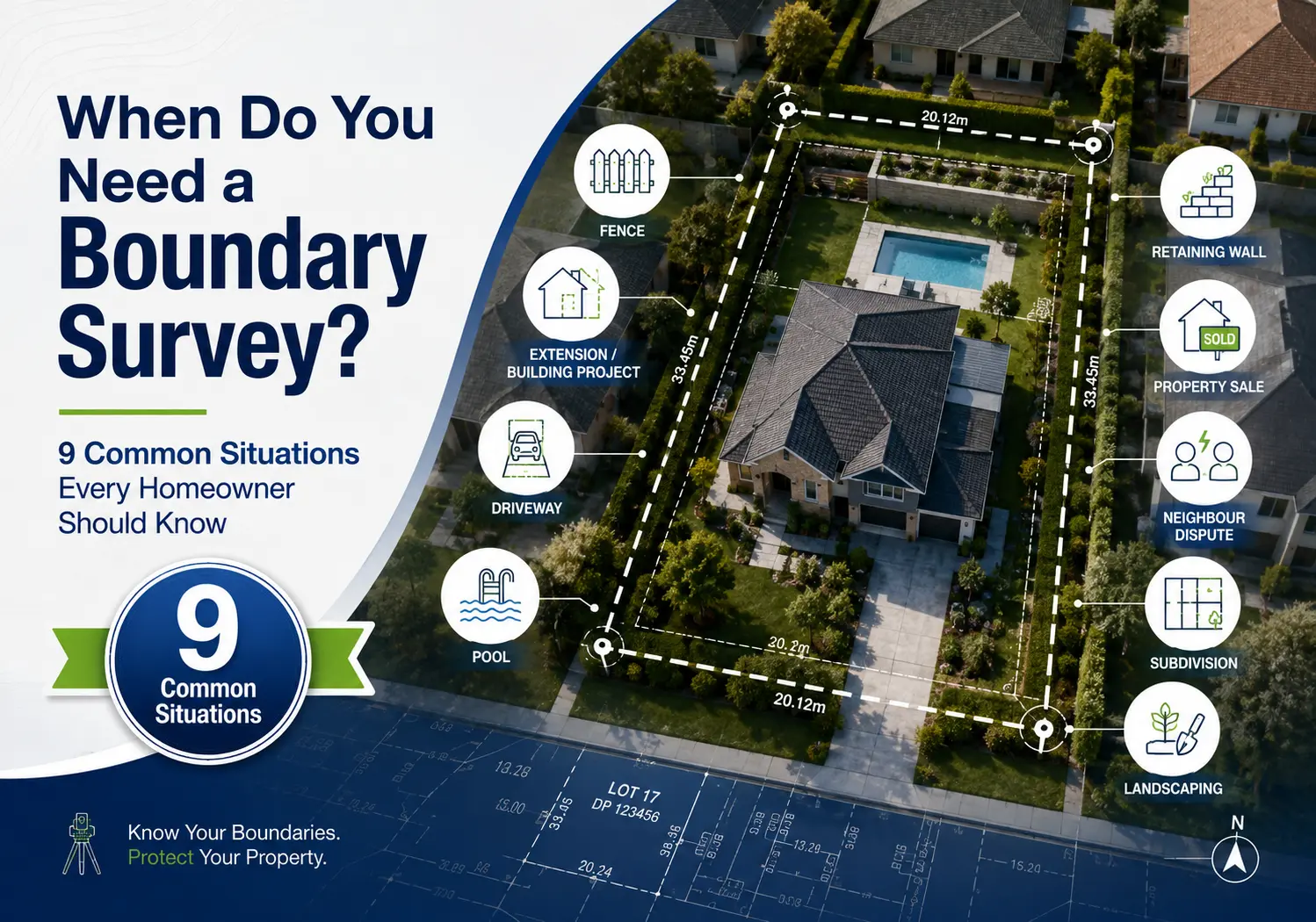
If someone has told you that you need a boundary survey, you must be wondering if it’s really necessary.
The answer depends on what you’re planning to do.
A boundary survey isn’t something every homeowner needs every year. But there are certain situations where knowing the exact legal boundary of your property can save you from expensive mistakes, delays, and disagreements later.
Whether you’re buying land, building a home, replacing a fence or planning an extension, understanding where your property begins and ends is an important first step.
In this guide, we’ll explain what a boundary survey is, when you need one and why it’s worth getting the right information before work begins.
What Is a Boundary Survey?
A boundary survey is a professional survey that identifies the legal boundaries of your property.
In simple terms, it answers one very important question:
Where does your land legally begin and end?
Many homeowners have an idea of where their property boundaries are. They use the existing fence, a retaining wall or even the neighbour’s garden as a guide.
Unfortunately, those things don’t always show the true legal boundary.
Over the years, fences can be moved, rebuilt or replaced without confirming the exact property line. Previous owners also have made changes that don’t match the legal boundaries shown on the property’s title.
A boundary survey removes the guesswork.
A registered surveyor carefully examines the available survey information, carries out accurate measurements on site, and determines the legal position of the property’s boundaries.
Boundary surveying forms part of the wider cadastral surveying work used to establish and document property boundaries. For homeowners, the important part is simple: a professional land surveyor gives you reliable boundary information rather than leaving you to rely on fences, old assumptions or rough measurements.
This gives you reliable information before you make important decisions about your land.
For many homeowners, a boundary survey provides confidence that they are working with accurate information rather than assumptions.
What Does a Boundary Survey Show?
Every property is different, but a boundary survey identifies the legal boundaries of your land and helps establish where they sit in relation to the existing site.
Depending on your property and the purpose of the survey, it helps identify:
- The legal boundary lines
- The corners of the property
- Existing buildings near the boundaries
- Fences in relation to the property
- Other visible improvements that can be close to the boundary
This information becomes valuable when you’re planning building work, replacing a fence or simply wanting confidence about where your property begins and ends.
It’s important to remember that a boundary survey is not simply someone measuring your fence with a tape measure.
Professional surveyors use specialised survey equipment together with the available property and survey information to determine the legal boundaries. SDMA uses modern GPS and robotic surveying equipment, supported by current surveying software, to produce accurate survey results across its residential, commercial, cadastral and construction surveying work.
Why Is a Boundary Survey Important?
Many property projects begin with excitement.
You’re planning a new home. You’re finally replacing the old fence. You’ve bought a block of land. You’re ready to build the extension you’ve wanted for years.
The last thing most people think about is whether they actually know where their property boundary is.
Unfortunately, this is where expensive problems can begin.
If construction starts in the wrong location, correcting the mistake later can become far more difficult than identifying the boundary before work begins.
A boundary survey gives everyone involved in the project the same starting point.
Instead of relying on assumptions, everyone works from accurate boundary information.
That benefits homeowners, builders, architects and developers by giving the people involved in the project reliable boundary information to work from. It can also make conversations with neighbours easier when questions about a shared boundary arise.
A boundary survey can help:
- Reduce uncertainty before construction starts
- Support planning and design decisions
- Help avoid building too close to neighbouring land
- Give confidence when replacing fences
- Provide reliable information if questions about boundaries arise
Think of it like building a house on the correct foundation.
Before anything else happens, you want to know you’re starting in the right place.
Does a Fence Show the Property Boundary?
This is probably the biggest misunderstanding homeowners have.
Many people naturally assume that if a fence has been standing for years, it must sit exactly on the property boundary.
Sometimes that’s true.
Sometimes it isn’t.
Fences can be affected by many things over the years.
They have been:
- Replaced by previous owners
- Moved during renovations
- Installed without a survey
- Built around existing trees or obstacles
- Positioned differently during earlier construction
After decades, nobody remembers exactly why the fence sits where it does.
As a result, the fence becomes accepted as the boundary even though it does not represent the legal property line.
That is why surveyors don’t simply look at the fence.
Instead, they use professional surveying methods together with official property information to determine where the legal boundary actually sits.
If you’re planning to build close to a fence, it’s worth confirming whether the fence and the legal boundary are in the same position before construction begins.
What Does a Surveyor Actually Do During a Boundary Survey?
Many homeowners imagine a surveyor arriving with measuring tape, checking a few points and leaving.
In reality, there’s much more involved.
The process starts before the surveyor even visits your property.
First, they review the available information relating to your property.
This helps them understand the land they will be surveying and prepare for the site visit.
Once on site, the surveyor collects accurate measurements using professional surveying equipment.
Depending on the property, they examine existing boundary evidence and compare their measurements with the available property information.
After the fieldwork is complete, the collected information is processed to determine the legal boundary positions.
The final outcome depends on the purpose of the survey, but it provides reliable boundary information that can then be used for your project.
While every property is different, the overall process includes:
- Reviewing available property information.
- Visiting the site.
- Collecting accurate measurements.
- Assessing the boundary information.
- Preparing the required survey information or documentation.
Most homeowners never see the work that happens before or after the site visit, but those stages are just as important as the measurements taken on the property.
When Do You Need a Boundary Survey?
There isn’t one situation where every homeowner needs a boundary survey.
Instead, there are several common situations where knowing the exact legal boundary becomes important.
Let’s look at the most common examples.
- Before Buying a Property
Buying property is one of the biggest financial decisions most people will ever make.
When you’re walking through a property, everything can appear straightforward.
The fences look normal.
The shed seems to fit comfortably in the backyard.
The driveway looks like it belongs entirely to the property.
But appearances don’t always tell the full story.
Without accurate boundary information, it’s difficult to know whether everything you see actually sits within the property’s legal boundaries.
For example, a garage can be very close to a neighbouring property.
A retaining wall could have been built many years ago. A fence may not follow the legal property line Most buyers won’t notice these things during an inspection. That’s why some property owners choose to arrange a boundary survey before completing the purchase.
Knowing this information early provides greater confidence about the property you’re buying.
It can also help you better understand the land before planning future improvements.
If you’re already thinking about extending the home, building a new garage or replacing fences after settlement, confirming the boundaries early gives you a much clearer starting point.
Buying property is already a major investment.
Having reliable boundary information can help you move forward with greater confidence.
- Before Selling Your Property
A boundary survey isn’t only useful for buyers.
It can also benefit sellers.
When preparing to sell your property, potential buyers ask questions about buildings, fences, or structures that sit close to the property’s boundaries.
Having accurate survey information available can provide reassurance during the sales process.
For example, buyers wonder:
- Is the shed inside the property?
- Does the fence follow the boundary?
- Is the garage built in the correct location?
While these questions don’t arise with every sale, having reliable boundary information available can make it easier to answer them.
Some buyers also feel more comfortable purchasing a property when important information has already been professionally checked.
If your property has older fences, buildings close to neighbouring land or improvements that were completed many years ago, discussing a boundary survey with your surveyor before listing the property can be worthwhile.
Every property is different, so the right approach depends on your circumstances.
- Before Building a New Home
Building a new home is an exciting milestone.
You’ve chosen your block.
You’re working with your designer or builder.
Plans are taking shape.
Construction is getting closer.
Before any of that turns into a finished home, it’s important to know exactly where the house can be built.
A new home isn’t simply placed anywhere on the block.
Its location needs to work with the property’s legal boundaries and the approved design.
If the building position is based on incorrect assumptions about the property boundaries, changes later in the project can become much more difficult.
That’s why accurate survey information is so valuable before construction begins.
A boundary survey provides reliable information that can support the planning process before work starts on site.
It also gives your design and construction team greater confidence that they’re working from accurate property information.
If you’re building your family home, you want to know you’re starting on the right foundation from day one.
That’s exactly why many homeowners choose to establish the property’s legal boundaries before construction begins.
Boundary surveying can also form one part of the wider residential survey work needed for a new home. Depending on the project, other surveying services may include a detail and contour survey during planning and a setout survey when the new home is ready to be positioned for construction.
- Before Building an Extension
A home extension is one of the most common reasons homeowners need a boundary survey.
Whether you’re adding another bedroom, extending your living area, or building a larger garage, the available space on your property becomes much more important.
Many extensions are built closer to the property’s boundaries than the original house. If the legal boundary isn’t where you think it is, it could affect the location of the new building.
A boundary survey helps remove that uncertainty before work begins.
It gives your architect, designer and builder accurate information about the property’s legal boundaries, allowing them to design with confidence from the start.
This can be particularly helpful if you’re planning to build:
- A room extension
- A garage
- A carport
- An outdoor entertaining area
- A granny flat
- A workshop
- A studio
The closer your project is to the edge of your property, the more important accurate boundary information becomes.
It is always easier to confirm the property’s legal boundaries before finalising building plans than to discover a problem after construction has already started.
Once the design progresses, the project may also require other surveying work. SDMA provides setout surveys for existing homes and extensions, helping transfer the required building positions from the plans onto the site before construction.
- Before Replacing a Fence
Replacing an old fence seems like a simple project.
The existing fence comes down.
The new fence goes up.
The job is finished.
Unfortunately, it isn’t always that straightforward.
One of the biggest assumptions homeowners make is that the current fence must already sit on the legal property boundary.
In many cases, it does.
But not always.
Fences have been replaced several times over many decades. Small changes in position can happen each time, especially if nobody confirms the legal boundary before installing the new fence.
Sometimes fences are deliberately offset because of trees, retaining walls or existing buildings.
In other situations, they were simply installed based on where people believed the boundary was at the time.
If you’re already spending thousands of dollars on a new fence, it makes sense to know you’re putting it in the correct location.
This is particularly worthwhile if:
- The existing fence looks unusually crooked.
- The neighbouring property has also changed over time.
- You’re unsure where the legal boundary sits.
- The new fence will be a significant investment.
- There have previously been questions about the boundary.
A boundary survey helps everyone start from the same information before construction begins.
- When Your Neighbour Is Building Near the Boundary
It can be stressful when construction starts next door.
You see excavation begin. Frames start going up. The building appears close to your fence.
Naturally, you begin wondering:
“Is that building actually inside their property?”
In many situations, everything is perfectly fine.
Builders are working from approved plans. Surveyors have already been involved. Construction is progressing exactly as it should.
But if you’re genuinely unsure where the boundary sits, it’s understandable to want accurate information rather than making assumptions.
A boundary survey helps you understand your property’s legal boundaries using professional surveying methods.
Having this information early is much more helpful than waiting until construction has progressed significantly.
It also allows conversations between neighbours to be based on facts rather than guesses.
Many neighbour disputes don’t start because someone intended to do the wrong thing. They start because both parties genuinely believe the boundary is somewhere different.
Accurate survey information helps remove much of that uncertainty.
If you’re unsure whether a boundary survey is the right service for your project, it’s worth understanding how it compares with other surveying services. Our simple guide to the different land surveys homeowners may need explains what each survey is designed to do and when it can be useful.
- When There’s a Boundary Dispute
Boundary disagreements can happen for many reasons.
Sometimes a fence has been standing in the same place for decades.
Sometimes new construction raises questions.
Sometimes both neighbours simply have different ideas about where the boundary sits.
These situations can quickly become stressful.
The longer uncertainty continues, the harder it becomes for everyone involved.
A boundary survey provides accurate information about the property’s legal boundaries.
Instead of relying on old fences, verbal agreements, or assumptions, everyone can refer to professionally determined boundary information.
This doesn’t mean every disagreement automatically disappears overnight.
However, having reliable information allows discussions to begin with facts rather than opinions.
If you think there can be uncertainty about your property’s boundaries, obtaining accurate information early is much easier than trying to resolve questions after major construction or landscaping has already been completed.
- Before Subdividing Your Land
Subdivision is one of the clearest situations where accurate boundary information is essential.
If you’re planning to divide one property into two or more separate lots, the existing property boundaries need to be clearly understood before the subdivision process moves forward.
Subdivision projects involve multiple professionals, including planners, designers, engineers, and surveyors.
Each relies on accurate information about the existing property.
A boundary survey helps establish that starting point.
From there, subdivision surveying deals with the work required to divide the land into new lots. SDMA provides subdivision surveys as part of its broader cadastral and development surveying services, with experience ranging from smaller residential projects through to multi-dwelling and larger-scale developments.
Whether you’re planning:
- A two-lot subdivision
- A multi-dwelling development
- A townhouse development
- A unit development
- A larger residential development
accurate boundary information gives the subdivision process a reliable starting point. It also reduces the risk of unexpected issues appearing later as the project progresses.
Subdivision is a significant investment. Starting with reliable property information gives the project a much stronger foundation.
- When Your Existing Survey Is Very Old
One question surveyors must hear is:
“I already have an old survey. Can I just use that?”
The answer depends on your project.
Land surveys don’t automatically expire.
However, they represent the property as it existed when the survey was completed.
Since then, things on or around the property may have changed
For example:
- New fences have been built.
- Buildings have been demolished.
- Extensions have been added.
- Roads have changed.
- Neighbouring properties have been redeveloped.
- Additional survey information may now be available in the surrounding area.
Surveying technology has also changed significantly over the years. SDMA uses current GPS and robotic survey equipment together with modern surveying software to produce accurate survey results. If you’re relying on much older survey information for a new project, it’s worth having a surveyor review it before deciding whether it is still suitable.
If your survey was completed many years ago and you’re planning a new project, it’s worth discussing whether updated survey information would be beneficial.
Rather than relying on assumptions, your surveyor can review the available information and advise whether the existing survey is suitable for your planned work.
Can a Boundary Survey Save You Money?
Many homeowners look at a boundary survey as another cost before construction begins.
A better way to think about it is as an investment in making informed decisions.
The survey itself doesn’t build your home, install your fence, or complete your extension.
What it does is provide accurate information before those larger investments begin.
Without that information, mistakes become much more expensive to fix.
For example, discovering that a new fence has been installed in the wrong position after construction is complete can involve additional labour, materials and time.
Finding out that building plans need to change after construction has started can create delays that affect the entire project.
Questions about property boundaries can also slow down property transactions, subdivision projects and future developments.
A boundary survey helps reduce these risks by giving everyone involved accurate information from the beginning.
While every project is different, many homeowners find that having reliable boundary information provides confidence throughout the planning and construction process.
If you’re also trying to budget for the surveying work, our simple explanation of land survey costs and pricing factors covers what can affect the price, why different survey types cost different amounts and what to consider before requesting a quote.
Common Mistakes Homeowners Make
Most boundary problems don’t happen because homeowners intentionally ignore the boundaries.
They happen because people make reasonable assumptions that turn out to be incorrect.
Some of the most common mistakes include:
Assuming the Fence Marks the Boundary
This is by far the most common misunderstanding.
An existing fence should never be treated as proof of the legal property boundary.
Starting Construction Before Confirming the Boundary
It’s exciting to begin building.
But starting too early without understanding the property’s legal boundaries can create avoidable problems later.
Using Old Property Information
An old survey can still be useful, but every project is different.
Before relying on older information, ask your surveyor whether it remains suitable for the work you’re planning.
Waiting Until There’s a Dispute
Many people only think about a boundary survey after a disagreement begins.
By then, conversations can already be stressful.
Obtaining accurate information earlier makes discussions much easier.
Guessing Which Survey You Need
A boundary survey is only one of several different land surveys.
Different projects can require different surveying services. SDMA’s residential surveying work includes detail and contour surveys for vacant land and existing homes, identification surveys for existing homes and structures, boundary surveys, and setout surveys for new homes and extensions.
Rather than guessing, explain your project to your surveyor and let them recommend the most appropriate service.
How Do You Know If You Need a Boundary Survey?
By now, you must be thinking:
“My project sounds a bit like several of these examples. How do I know if I actually need a boundary survey?”
The good news is that you don’t need to figure it out on your own.
Most homeowners aren’t expected to know the difference between a boundary survey, an identification survey, or a detail and contour survey.
That’s the surveyor’s job.
The best thing you can do is explain your project.
Tell your surveyor:
- What you’re planning to do.
- Whether you’ve already purchased the property.
- If you’re building, renovating or subdividing.
- Whether construction will be close to a boundary.
- If you’ve noticed any uncertainty about your property’s boundaries.
- Whether you already have previous survey plans.
From there, your surveyor can recommend the most suitable survey.
In some situations, a boundary survey will be the right choice.
In others, another type of survey provides the information your project actually needs.
For example, if you’re designing a new home or extension, a detail and contour survey may also be needed to provide information about the existing site for the design process.
If terms such as boundary survey, identification survey, detail survey and building setout are starting to sound confusing, our homeowner-friendly explanation of the different survey types shows what each one does and when it can be relevant to a property project.
What Information Should You Have Before Contacting a Surveyor?
You don’t need to gather lots of technical documents before requesting a quote.
However, having some basic information ready makes it easier for the surveyor to understand your project.
Helpful information includes:
Your property address
The surveyor will need to know where the property is located.
What you’re planning to do
For example:
- Build a new home
- Construct an extension
- Replace a fence
- Buy or sell the property
- Subdivide the land
A simple explanation is enough.
Existing plans or drawings
If you already have architectural drawings, concept plans or previous survey plans, they help the surveyor understand your project.
Don’t worry if you don’t have them yet.
Many homeowners contact a surveyor before detailed plans have even been prepared.
Any concerns you already have
For example:
- You’re unsure where the boundary is.
- Your neighbour is building close to the fence.
- The existing fence looks unusual.
- You’re concerned about available space.
Sharing these concerns early allows the surveyor to understand what information will be most useful.
Simple Checklist: Do You Need a Boundary Survey?
You can benefit from a boundary survey if you answer Yes to any of these questions.
- Are you buying a property?
- Are you selling a property with buildings close to the boundaries?
- Are you planning to build a new home?
- Are you building an extension near your property boundary?
- Are you replacing a boundary fence?
- Is your neighbour building close to your property?
- Are you planning to subdivide your land?
- Are you unsure where your legal property boundary is?
- Is your existing survey many years old?
If you answered yes to one or more of these questions, it’s worth discussing your project with a professional surveyor.
Boundary Survey vs Other Land Surveys
One reason homeowners become confused is that there are several different types of land surveys.
Although they all involve measuring land, they don’t all answer the same question.
Here’s a simple comparison.
| Survey Type | Main Purpose |
| Boundary Survey | Establishes the legal boundaries of the property. |
| Detail & Contour Survey | Records existing site features and levels for vacant land or existing homes. |
| Identification Survey | Records the position of existing homes or structures in relation to the property. |
| Building Setout Survey | Establishes required construction positions for new homes and extensions. |
| Subdivision Survey | Supports the surveying work involved in dividing land into new lots. |
| Unit & Strata Surveying | Supports unit developments, unit plans, unit titles and strata survey plans. |
| Engineering Setout Survey | Provides setout surveying for engineering and civil construction projects. |
Choosing the right survey at the beginning helps ensure your project starts with the correct information.
Frequently Asked Questions
How long does a boundary survey take?
The time required depends on the size of the property, site conditions, the complexity of the land, and the work involved.
Some projects are straightforward, while others require additional research and fieldwork.
Your surveyor can provide a more accurate timeframe after understanding your project.
Do I need to be home during the survey?
Every project is different.
Depending on the property and site access, your surveyor will let you know whether someone needs to be present during the survey.
Can I use an old boundary survey?
Possibly.
An older survey still contains useful information, but whether it is suitable depends on your project and any changes that have occurred since it was completed.
Your surveyor can review any existing plans and advise whether updated survey information is recommended.
Will a boundary survey solve a dispute with my neighbour?
A boundary survey provides accurate information about the legal property boundaries.
Having reliable information helps everyone understand where the legal boundary is and provides a factual starting point for any discussions.
Can Google Maps tell me where my property boundary is?
No.
Online maps are useful for finding locations, but they should not be relied on to identify legal property boundaries.
A professional boundary survey is needed when accurate boundary information is required.
Is every fence built on the property boundary?
No.
Many fences sit close to the boundary, but they are not automatically proof of the legal property line.
That’s why existing fences should never be used as the only guide when planning construction.
What happens after the survey is completed?
After the fieldwork is completed, the surveyor processes the information collected and prepares the survey information or documentation required for the particular job. What you receive depends on the purpose of the boundary survey, so your surveyor can explain the final information and how it should be used for your project.
Your surveyor will explain the information provided and how it can be used for your project.
I’m still not sure which survey I need. What should I do?
That’s completely normal.
Most homeowners don’t know which survey is appropriate until they speak with a surveyor.
Simply explain your project and your surveyor can recommend the service that best suits your needs.
The Right Information at the Beginning Can Save Problems Later
Many homeowners only think about a boundary survey after someone tells them they need one.
In reality, it’s one of the first steps that can help provide confidence before buying, building, extending or subdividing a property.
Knowing where your property’s legal boundaries are gives you, your builder, architect, designer or developer reliable information to work from. Where neighbouring properties are involved, it can also make boundary discussions much clearer.
It removes guesswork from important decisions and helps reduce the risk of unexpected issues later in the project.
Every property is different.
Every project is different.
That’s why there isn’t one answer that suits everyone.
The important thing is making sure you have the right information before making major decisions about your land.
Need a Boundary Survey in Canberra?
If you’re planning to buy property, build a new home, replace a fence, extend your house or subdivide your land, the team at Scott D McNiven & Associates Pty Ltd can help.
For over 35 years, SDMA has been conducting Registered and Construction survey services throughout Canberra and surrounding NSW. Our experience covers residential, commercial, civil engineering, cadastral and boundary surveying for individual homeowners, builders, developers, architects and large-scale construction companies.
Our experienced team works across projects ranging from residential detail, setout and boundary surveys through to subdivisions, multi-dwelling developments, townhouse and apartment complexes, commercial setouts and large civil and engineering projects. We use current GPS, robotic and drone survey equipment, supported by modern surveying software, to deliver high-quality survey services and accurate results.
If you’re unsure whether you need a boundary survey or another surveying service, our team can discuss your project and help you understand the appropriate next step.
Contact SDMA to discuss your next project and obtain an obligation-free quote.